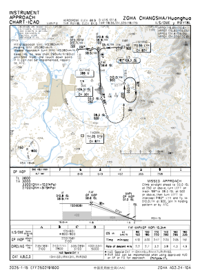
IAC chart of ZGHA
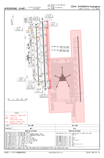
 ADC chart of ZGHA
 Satellite view of ZGHA

ADC chart of ZGHA
Satellite view of ZGHA
Sorry, we have no imagery here.
Sorry, we have no imagery here.
Sorry, we have no imagery here.
Sorry, we have no imagery here.
Sorry, we have no imagery here.
Sorry, we have no imagery here.


ZGHA - Changsha/Huanghua
Located in Changsha, China
ICAO - ZGHA, IATA - CSX
Data provided by AirmateGeneral information
Coordinates: N28°11'24" E113°13'6"
Elevation is 220 feet MSL.
View others Airports in Hunan Province
Operational data
Special qualification required
Current time UTC: 05:10:38
Current local time:
Weather
METAR: ZGHA 290500Z 02003MPS 310V080 9999 BKN040 27/18 Q1013 NOSIG
TAF: TAF ZGHA 290303Z 2906/3006 17004MPS 4000 BR SCT050 TX28/2907Z TN21/2922Z
Communications frequencies: [VIEW]
Runways:
| RWY identifier | QFU | Length (ft) | Width (ft) | Surface | LDA (ft) |
| 18R | 177° | 10499 | 148 | UNK | |
| 36L | 357° | 10499 | 148 | UNK | |
| 18L | 177° | 12467 | 197 | UNK | |
| 36R | 357° | 12467 | 197 | UNK |
Airport contact information
Address: Changsha China
Satellite view of ZGHA
Sorry, we have no imagery here.
Sorry, we have no imagery here.
Sorry, we have no imagery here.
Sorry, we have no imagery here.
Sorry, we have no imagery here.
Sorry, we have no imagery here.