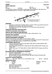


YGIG - Gingin
Located in , Australia
ICAO - YGIG, IATA -
Data provided by AirmateGeneral information
Coordinates: S31°27'55" E115°51'48"
Elevation is 247 feet MSL.
View others Airports in Western Australia
Operational data
Special qualification required
Current time UTC:
Current local time:
Weather at : YPEA - Pearce ( 27 km )
METAR: YPEA 131000Z 18008KT 9999 BKN011 21/19 Q1008
TAF: TAF AMD YPEA 131017Z 1311/1400 20008KT 9999 -SHRA BKN010 FM131200 18003KT 9999 -SHRA SCT010 BKN020 FM131500 35005KT 9999 NSW SCT030 INTER 1312/1313 9999 BKN010
Communications frequencies: [VIEW]
Runways:
| RWY identifier | QFU | Length (ft) | Width (ft) | Surface | LDA (ft) |
| 08 | 75° | 5997 | 148 | ASP | |
| 26 | 255° | 5997 | 148 | ASP |
Airport contact information
Address: Australia