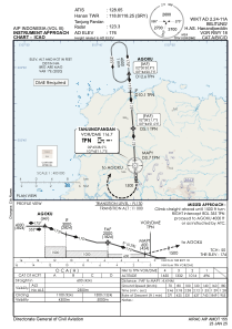
IAC chart of WIKT
 Satellite view of WIKT

Satellite view of WIKT
Sorry, we have no imagery here.
Sorry, we have no imagery here.
Sorry, we have no imagery here.
Sorry, we have no imagery here.
Sorry, we have no imagery here.
Sorry, we have no imagery here.


WIKT - Tanjung Pandan / H. As. Hanandjoeddin
Located in Tanjung Pandan, Indonesia
ICAO - , IATA - TJQ
Data provided by AirmateGeneral information
Coordinates: S2°44'43" E107°45'11"
Elevation is 176 feet MSL.
View others Airports in Bangka Belitung
Operational data
Special qualification required
Current time UTC: 16:42:45
Current local time:
Weather at : - ( 0 km )
METAR: KQFX 301640Z AUTO 00000KT 9999 CLR 13/11 A2990 RMK A02 TSNO
Communications frequencies: [VIEW]
Runways:
| RWY identifier | QFU | Length (ft) | Width (ft) | Surface | LDA (ft) |
| 18 | 176° | 8202 | 148 | UNK | |
| 36 | 356° | 8202 | 148 | UNK |
Airport contact information
Address: Tanjung Pandan Indonesia
Satellite view of WIKT
Sorry, we have no imagery here.
Sorry, we have no imagery here.
Sorry, we have no imagery here.
Sorry, we have no imagery here.
Sorry, we have no imagery here.
Sorry, we have no imagery here.