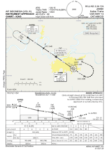
IAC chart of WIJJ
 Satellite view of WIJJ

Satellite view of WIJJ
Sorry, we have no imagery here.
Sorry, we have no imagery here.
Sorry, we have no imagery here.
Sorry, we have no imagery here.
Sorry, we have no imagery here.
Sorry, we have no imagery here.


WIJJ - Jambi / Sultan Thaha
Located in Jambi, Indonesia
ICAO - , IATA - DJB
Data provided by AirmateGeneral information
Coordinates: S1°38'8" E103°38'35"
Elevation is 92 feet MSL.
View others Airports in Jambi
Operational data
Special qualification required
Current time UTC: 19:17:36
Current local time:
Weather at : - ( 0 km )
METAR: PAOU 301913Z AUTO 24013G17KT 4SM -RA BR OVC004 04/03 A2980 RMK AO2 CIG 003V007 P0000
Communications frequencies: [VIEW]
Runways:
| RWY identifier | QFU | Length (ft) | Width (ft) | Surface | LDA (ft) |
| 13 | 129° | 8537 | 148 | UNK | |
| 31 | 309° | 8537 | 148 | UNK |
Airport contact information
Address: Jambi Indonesia
Satellite view of WIJJ
Sorry, we have no imagery here.
Sorry, we have no imagery here.
Sorry, we have no imagery here.
Sorry, we have no imagery here.
Sorry, we have no imagery here.
Sorry, we have no imagery here.