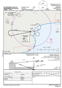
IAC chart of WICN
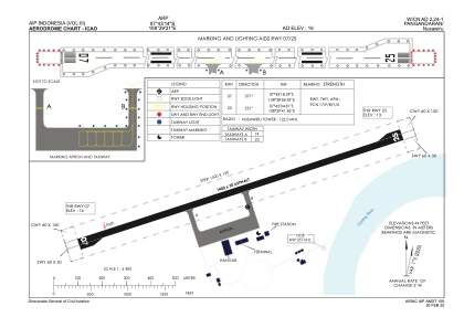
 ADC chart of WICN
 Satellite view of WICN

ADC chart of WICN
Satellite view of WICN
Sorry, we have no imagery here.
Sorry, we have no imagery here.
Sorry, we have no imagery here.
Sorry, we have no imagery here.
Sorry, we have no imagery here.
Sorry, we have no imagery here.


WICN - Pangandaran / Nusawiru
Located in Pangandaran, Indonesia
ICAO - , IATA - CJN
Data provided by AirmateGeneral information
Coordinates: S7°43'14" E108°29'21"
Elevation is 16 feet MSL.
View others Airports in Jawa Barat
Operational data
Special qualification required
Current time UTC: 16:24:06
Current local time:
Weather at : - ( 0 km )
METAR: UHMA 301621Z 02014G19MPS 9999 SCT018 BKN032 M01/M04 Q0990 R02/////// NOSIG RMK MID 03016G21MPS END R02/03013G19MPS QFE739/0985
Communications frequencies: [VIEW]
Runways:
| RWY identifier | QFU | Length (ft) | Width (ft) | Surface | LDA (ft) |
| 07 | 72° | 4593 | 98 | UNK | |
| 25 | 252° | 4593 | 98 | UNK |
Airport contact information
Address: Pangandaran Indonesia
Satellite view of WICN
Sorry, we have no imagery here.
Sorry, we have no imagery here.
Sorry, we have no imagery here.
Sorry, we have no imagery here.
Sorry, we have no imagery here.
Sorry, we have no imagery here.