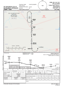
IAC chart of WIBL
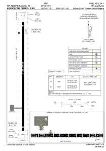
 ADC chart of WIBL
 Satellite view of WIBL

ADC chart of WIBL
Satellite view of WIBL
Sorry, we have no imagery here.
Sorry, we have no imagery here.
Sorry, we have no imagery here.
Sorry, we have no imagery here.
Sorry, we have no imagery here.
Sorry, we have no imagery here.


WIBL - Sultan Syarif Haroen Setia Negara
Located in Pelalawan, Indonesia
ICAO - , IATA -
Data provided by AirmateGeneral information
Coordinates: N0°30'17" E101°55'22"
Elevation is 95 feet MSL.
Magnetic variation is 0° East View others Airports in Riau
Operational data
Special qualification required
Current time UTC: 08:22:12
Current local time:
Weather at : WIBB - Pekanbaru/Sultan Syarif Kasim Ii ( 53 km )
METAR: WIBB 210800Z 00000KT 9999 BKN013 32/25 Q1004 NOSIG
Communications frequencies: [VIEW]
Runways:
| RWY identifier | QFU | Length (ft) | Width (ft) | Surface | LDA (ft) |
| 18 | 180° | 5446 | 98 | UNK | |
| 36 | 360° | 5446 | 98 | UNK |
Airport contact information
Address: Pelalawan Indonesia
Satellite view of WIBL
Sorry, we have no imagery here.
Sorry, we have no imagery here.
Sorry, we have no imagery here.
Sorry, we have no imagery here.
Sorry, we have no imagery here.
Sorry, we have no imagery here.