ADC chart of WARC
 Satellite view of WARC

Satellite view of WARC
Sorry, we have no imagery here.
Sorry, we have no imagery here.
Sorry, we have no imagery here.
Sorry, we have no imagery here.
Sorry, we have no imagery here.
Sorry, we have no imagery here.


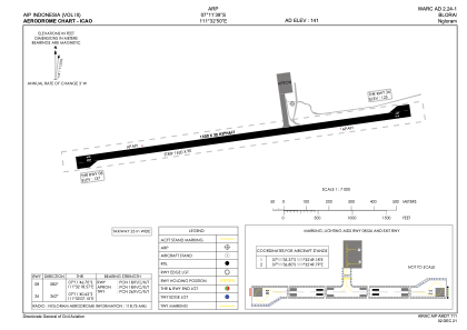
WARC - Blora / Ngloram
Located in Cepu, Indonesia
ICAO - WARC, IATA - CPF
Data provided by AirmateGeneral information
Coordinates: S7°11'39" E111°32'50"
Elevation is 141 feet MSL.
View others Airports in Jawa Tengah
Operational data
Special qualification required
Current time UTC: 02:34:47
Current local time:
Weather at : - ( 0 km )
METAR: ZMCK 210230Z 32007MPS 9999 BKN100 11/M04 Q1026 NOSIG
Communications frequencies: [VIEW]
Runways:
| RWY identifier | QFU | Length (ft) | Width (ft) | Surface | LDA (ft) |
| 08 | 83° | 4921 | 98 | ASP | |
| 26 | 263° | 4921 | 98 | ASP |
Airport contact information
Address: Cepu Indonesia
Satellite view of WARC
Sorry, we have no imagery here.
Sorry, we have no imagery here.
Sorry, we have no imagery here.
Sorry, we have no imagery here.
Sorry, we have no imagery here.
Sorry, we have no imagery here.