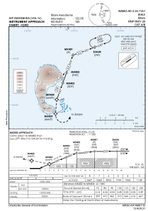
IAC chart of WAMO
 Satellite view of WAMO

Satellite view of WAMO
Sorry, we have no imagery here.
Sorry, we have no imagery here.
Sorry, we have no imagery here.
Sorry, we have no imagery here.
Sorry, we have no imagery here.
Sorry, we have no imagery here.


WAMO - Siau / Sitaro
Located in Ulu Siau, Indonesia
ICAO - , IATA -
Data provided by AirmateGeneral information
Coordinates: N2°39'11" E125°25'29"
Elevation is 155 feet MSL.
Magnetic variation is 0° East View others Airports in Sulawesi Utara
Operational data
Special qualification required
Current time UTC: 08:46:05
Current local time:
Weather at : - ( 0 km )
METAR: KLNK 280843Z AUTO 34004KT 10SM BKN018 11/10 A3015 RMK AO2 T01110100
Communications frequencies: [VIEW]
Runways:
| RWY identifier | QFU | Length (ft) | Width (ft) | Surface | LDA (ft) |
| 02 | 0° | 4347 | 98 | UNK | |
| 20 | 0° | 4347 | 98 | UNK |
Airport contact information
Address: Ulu Siau Indonesia
Satellite view of WAMO
Sorry, we have no imagery here.
Sorry, we have no imagery here.
Sorry, we have no imagery here.
Sorry, we have no imagery here.
Sorry, we have no imagery here.
Sorry, we have no imagery here.