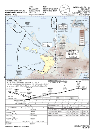
IAC chart of WAMM
 Satellite view of WAMM

Satellite view of WAMM
Sorry, we have no imagery here.
Sorry, we have no imagery here.
Sorry, we have no imagery here.
Sorry, we have no imagery here.
Sorry, we have no imagery here.
Sorry, we have no imagery here.


WAMM - Manado/Sam Ratulangi
Located in Manado, Indonesia
ICAO - WAMM, IATA - MDC
Data provided by AirmateGeneral information
Coordinates: N1°32'44" E124°55'30"
Elevation is 328 feet MSL.
View others Airports in Sulawesi Utara
Operational data
Special qualification required
Current time UTC: 15:40:30
Current local time:
Weather
METAR: WAMM 251530Z VRB01KT 9999 SCT019 24/24 Q1013 NOSIG METAR WIDN NIL
Communications frequencies: [VIEW]
Runways:
| RWY identifier | QFU | Length (ft) | Width (ft) | Surface | LDA (ft) |
| 18 | 182° | 8694 | 148 | ASP | |
| 36 | 2° | 8694 | 148 | ASP |
Airport contact information
Address: Manado Indonesia
Satellite view of WAMM
Sorry, we have no imagery here.
Sorry, we have no imagery here.
Sorry, we have no imagery here.
Sorry, we have no imagery here.
Sorry, we have no imagery here.
Sorry, we have no imagery here.