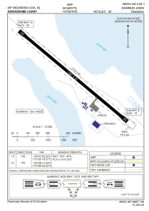
ADC chart of WAHU
 Satellite view of WAHU

Satellite view of WAHU
Sorry, we have no imagery here.
Sorry, we have no imagery here.
Sorry, we have no imagery here.
Sorry, we have no imagery here.
Sorry, we have no imagery here.
Sorry, we have no imagery here.


WAHU - Karimun Jawa/Dewadaru
Located in Alun-Alun Karimunjawa, Indonesia
ICAO - , IATA - KWB
Data provided by AirmateGeneral information
Coordinates: S5°48'7" E110°28'40"
Elevation is 30 feet MSL.
Magnetic variation is 1° East View others Airports in Jawa Tengah
Operational data
Special qualification required
Current time UTC: 18:28:51
Current local time:
Weather at : - ( 0 km )
METAR: PASD 271826Z 30008KT 10SM FEW017 SCT035 SCT060 09/06 A2945 RMK AO2 $
Communications frequencies: [VIEW]
Runways:
| RWY identifier | QFU | Length (ft) | Width (ft) | Surface | LDA (ft) |
| 13 | 130° | 4593 | 98 | UNK | |
| 31 | 310° | 4593 | 98 | UNK |
Airport contact information
Address: Alun-Alun Karimunjawa Indonesia
Satellite view of WAHU
Sorry, we have no imagery here.
Sorry, we have no imagery here.
Sorry, we have no imagery here.
Sorry, we have no imagery here.
Sorry, we have no imagery here.
Sorry, we have no imagery here.