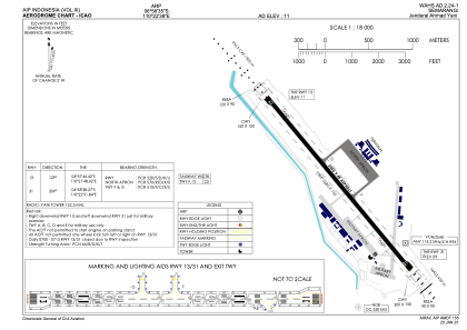
ADC chart of WAHS
 Satellite view of WAHS

Satellite view of WAHS
Sorry, we have no imagery here.
Sorry, we have no imagery here.
Sorry, we have no imagery here.
Sorry, we have no imagery here.
Sorry, we have no imagery here.
Sorry, we have no imagery here.


WAHS - Semarang / Jenderal Ahmad Yani
Located in Semarang, Indonesia
ICAO - , IATA - SRG
Data provided by AirmateGeneral information
Coordinates: S6°58'35" E110°22'38"
Elevation is 13 feet MSL.
View others Airports in Jawa Tengah
Operational data
Special qualification required
Current time UTC: 19:35:02
Current local time:
Weather
METAR: WAHS 241900Z AUTO 12003KT 5000 FEW019 SCT022 BKN042 26/26 Q1007
Communications frequencies: [VIEW]
Runways:
| RWY identifier | QFU | Length (ft) | Width (ft) | Surface | LDA (ft) |
| 13 | 130° | 8399 | 148 | UNK | |
| 31 | 310° | 8399 | 148 | UNK |
Airport contact information
Address: Semarang Indonesia
Satellite view of WAHS
Sorry, we have no imagery here.
Sorry, we have no imagery here.
Sorry, we have no imagery here.
Sorry, we have no imagery here.
Sorry, we have no imagery here.
Sorry, we have no imagery here.