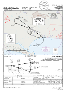
IAC chart of WAHL
 Satellite view of WAHL
Satellite view of WAHL
Sorry, we have no imagery here.
Sorry, we have no imagery here.
Sorry, we have no imagery here.
Sorry, we have no imagery here.
Sorry, we have no imagery here.
Sorry, we have no imagery here.


WAHL - Cilacap / Tunggul Wulung
Located in Cilacap, Indonesia
ICAO - , IATA - CXP
Data provided by AirmateGeneral information
Coordinates: S7°38'40" E109°2'5"
Elevation is 84 feet MSL.
View others Airports in Jawa Tengah
Operational data
Special qualification required
Current time UTC: 14:29:42
Current local time:
Weather at : - ( 0 km )
METAR: UUEE 281426Z 15007G12MPS 120V180 CAVOK 27/03 Q1017 R06R/CLRD62 R06C/CLRD62 NOSIG
Communications frequencies: [VIEW]
Runways:
| RWY identifier | QFU | Length (ft) | Width (ft) | Surface | LDA (ft) |
| 13 | 133° | 4593 | 98 | UNK | |
| 31 | 313° | 4593 | 98 | UNK |
Airport contact information
Address: Cilacap Indonesia
Satellite view of WAHL
Sorry, we have no imagery here.
Sorry, we have no imagery here.
Sorry, we have no imagery here.
Sorry, we have no imagery here.
Sorry, we have no imagery here.
Sorry, we have no imagery here.