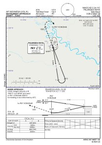
IAC chart of WAGG
 Satellite view of WAGG
Satellite view of WAGG
Sorry, we have no imagery here.
Sorry, we have no imagery here.
Sorry, we have no imagery here.
Sorry, we have no imagery here.
Sorry, we have no imagery here.
Sorry, we have no imagery here.


WAGG - Palangka Raya / Tjilik Riwut
Located in Palangka Raya, Indonesia
ICAO - , IATA - PKY
Data provided by AirmateGeneral information
Coordinates: S2°13'36" E113°56'40"
Elevation is 40 feet MSL.
View others Airports in (unassigned)
Operational data
Special qualification required
Current time UTC: 07:53:24
Current local time:
Weather at : - ( 0 km )
METAR: KAFP 300751Z AUTO 00000KT 10SM OVC006 20/19 A2990 RMK AO2 P0004 T01960190
Communications frequencies: [VIEW]
Runways:
| RWY identifier | QFU | Length (ft) | Width (ft) | Surface | LDA (ft) |
| 16 | 159° | 8202 | 148 | UNK | |
| 34 | 339° | 8202 | 148 | UNK |
Airport contact information
Address: Palangka Raya Indonesia
Satellite view of WAGG
Sorry, we have no imagery here.
Sorry, we have no imagery here.
Sorry, we have no imagery here.
Sorry, we have no imagery here.
Sorry, we have no imagery here.
Sorry, we have no imagery here.