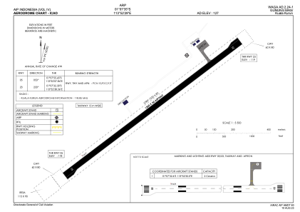
ADC chart of WAGA
 Satellite view of WAGA

Satellite view of WAGA
Sorry, we have no imagery here.
Sorry, we have no imagery here.
Sorry, we have no imagery here.
Sorry, we have no imagery here.
Sorry, we have no imagery here.
Sorry, we have no imagery here.


WAGA - Gunung Mas / Kuala Kurun
Located in Kuala Kurun, Indonesia
ICAO - , IATA -
Data provided by AirmateGeneral information
Coordinates: S1°7'35" E113°52'29"
Elevation is 127 feet MSL.
Magnetic variation is 0° East View others Airports in (unassigned)
Operational data
Special qualification required
Current time UTC: 14:03:34
Current local time:
Weather at : - ( 0 km )
METAR: ZMUB 301400Z 04003MPS CAVOK 05/M10 Q1014 NOSIG RMK QFE653.5 33
Communications frequencies: [VIEW]
Runways:
| RWY identifier | QFU | Length (ft) | Width (ft) | Surface | LDA (ft) |
| 05 | 53° | 3937 | 98 | UNK | |
| 23 | 233° | 3937 | 98 | UNK |
Airport contact information
Address: Kuala Kurun Indonesia
Satellite view of WAGA
Sorry, we have no imagery here.
Sorry, we have no imagery here.
Sorry, we have no imagery here.
Sorry, we have no imagery here.
Sorry, we have no imagery here.
Sorry, we have no imagery here.