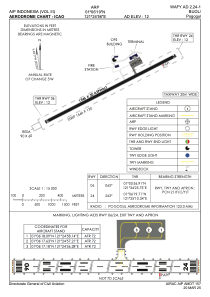
ADC chart of WAFY
 Satellite view of WAFY
Satellite view of WAFY
Sorry, we have no imagery here.
Sorry, we have no imagery here.
Sorry, we have no imagery here.
Sorry, we have no imagery here.
Sorry, we have no imagery here.
Sorry, we have no imagery here.


WAFY - Buol / Pogogul
Located in Buol, Indonesia
ICAO - , IATA - UOL
Data provided by AirmateGeneral information
Coordinates: N1°6'19" E121°24'56"
Elevation is 12 feet MSL.
View others Airports in Sulawesi Tengah
Operational data
Special qualification required
Current time UTC: 21:16:13
Current local time:
Weather at : - ( 0 km )
METAR: KY19 272115Z AUTO 16011G19KT 10SM CLR 18/10 A3019 RMK AO2
Communications frequencies: [VIEW]
Runways:
| RWY identifier | QFU | Length (ft) | Width (ft) | Surface | LDA (ft) |
| 06 | 63° | 5072 | 98 | UNK | |
| 24 | 243° | 5072 | 98 | UNK |
Airport contact information
Address: Buol Indonesia
Satellite view of WAFY
Sorry, we have no imagery here.
Sorry, we have no imagery here.
Sorry, we have no imagery here.
Sorry, we have no imagery here.
Sorry, we have no imagery here.
Sorry, we have no imagery here.