ADC chart of WA14
 Satellite view of WA14

Satellite view of WA14
Sorry, we have no imagery here.
Sorry, we have no imagery here.
Sorry, we have no imagery here.
Sorry, we have no imagery here.
Sorry, we have no imagery here.
Sorry, we have no imagery here.


WA14 - Connell City
Located in Connell, United States
ICAO - WA14, IATA -
Data provided by AirmateGeneral information
Coordinates: N46°39'41" W118°49'50"
Elevation is 925 feet MSL.
Magnetic variation is 19° East View others Airports in Washington
Operational data
Special qualification required
Current time UTC: 04:02:40
Current local time:
Weather at : KPSC - Tri-Cities ( 49 km )
METAR: KPSC 260353Z 26015G29KT 10SM TS OVC100 26/07 A2977 RMK AO2 PK WND 24030/0341 RAE53 TSB42 SLP076 P0000 T02560067 $
TAF: KPSC 252329Z 2600/2624 33005KT P6SM SCT120 SCT250 PROB30 2601/2603 -SHRA SCT070 OVC090 FM260300 25011G17KT P6SM -SHRA SCT060 OVC080 PROB30 2603/2607 VRB15G30KT 6SM -TSRA BKN060CB FM260800 22011KT P6SM BKN100 FM261800 22010KT P6SM BKN250 FM262100 24012G20KT P6SM FEW250
Communications frequencies: [VIEW]
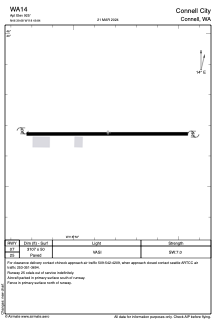
Runways:
| RWY identifier | QFU | Length (ft) | Width (ft) | Surface | LDA (ft) |
| 07 | 0° | 3107 | 50 | ASPH | |
| 25 | 0° | 3107 | 50 | ASPH |
Airport contact information
Address: Connell United States
Satellite view of WA14
Sorry, we have no imagery here.
Sorry, we have no imagery here.
Sorry, we have no imagery here.
Sorry, we have no imagery here.
Sorry, we have no imagery here.
Sorry, we have no imagery here.