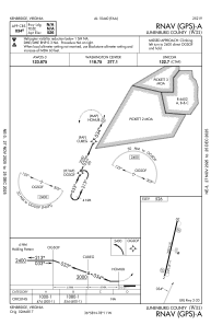
IAC chart of W31
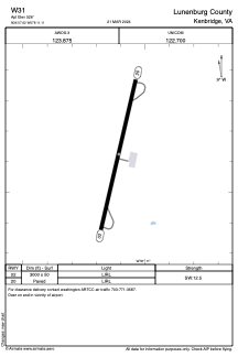
 ADC chart of W31
 Satellite view of W31

ADC chart of W31
Satellite view of W31
Sorry, we have no imagery here.
Sorry, we have no imagery here.
Sorry, we have no imagery here.
Sorry, we have no imagery here.
Sorry, we have no imagery here.
Sorry, we have no imagery here.


W31 - Lunenburg County
Located in Kenbridge, United States
ICAO - W31, IATA -
Data provided by AirmateGeneral information
Coordinates: N36°57'37" W78°11'6"
Elevation is 526 feet MSL.
Magnetic variation is -10° East View others Airports in Virginia
Operational data
Special qualification required
Current time UTC: 21:04:18
Current local time:
Weather at : KBKT - Allan C Perkinson/Blackstone Aaf ( 24 km )
METAR: KBKT 292055Z AUTO 22004KT 7SM BKN014 OVC019 23/20 A2999 RMK AO2 BKN V OVC SLP157 T02290198 57021
Communications frequencies: [VIEW]
Runways:
| RWY identifier | QFU | Length (ft) | Width (ft) | Surface | LDA (ft) |
| 02 | 13° | 3000 | 50 | ASPH | |
| 20 | 193° | 3000 | 50 | ASPH |
Airport contact information
Address: Kenbridge United States
Satellite view of W31
Sorry, we have no imagery here.
Sorry, we have no imagery here.
Sorry, we have no imagery here.
Sorry, we have no imagery here.
Sorry, we have no imagery here.
Sorry, we have no imagery here.