ADC chart of W20
 Satellite view of W20

Satellite view of W20
Sorry, we have no imagery here.
Sorry, we have no imagery here.
Sorry, we have no imagery here.
Sorry, we have no imagery here.
Sorry, we have no imagery here.
Sorry, we have no imagery here.


W20 - Moses Lake Muni
Located in Moses Lake, United States
ICAO - W20, IATA -
Data provided by AirmateGeneral information
Coordinates: N47°8'31" W119°14'16"
Elevation is 1205 feet MSL.
Magnetic variation is 19° East View others Airports in Washington
Operational data
Special qualification required
Current time UTC: 11:18:29
Current local time:
Weather at : KMWH - Grant County Intl ( 10 km )
METAR: KMWH 301052Z AUTO 27004KT 10SM CLR 12/04 A3020 RMK AO2 SLP223 T01220039
TAF: KMWH 300525Z 3006/3106 26010KT P6SM FEW250 FM301300 VRB04KT P6SM FEW250 FM301800 19006KT P6SM FEW250
Communications frequencies: [VIEW]
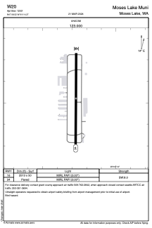
Runways:
| RWY identifier | QFU | Length (ft) | Width (ft) | Surface | LDA (ft) |
| 16 | 0° | 2513 | 50 | ASPH | |
| 34 | 0° | 2513 | 50 | ASPH |
Airport contact information
Address: Moses Lake United States
