ADC chart of W16
 Satellite view of W16

Satellite view of W16
Sorry, we have no imagery here.
Sorry, we have no imagery here.
Sorry, we have no imagery here.
Sorry, we have no imagery here.
Sorry, we have no imagery here.
Sorry, we have no imagery here.


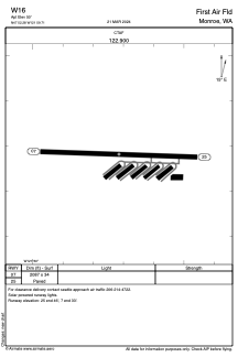
W16 - First Air Fld
Located in Monroe, United States
ICAO - W16, IATA -
Data provided by AirmateGeneral information
Coordinates: N47°52'17" W121°59'43"
Elevation is 50 feet MSL.
Magnetic variation is 20° East View others Airports in Washington
Operational data
Special qualification required
Current time UTC: 13:04:48
Current local time:
Weather at : KPAE - Seattle Paine Fld Intl ( 22 km )
METAR: KPAE 301253Z AUTO 35003KT 10SM CLR 08/06 A3026 RMK AO2 SLP249 T00830061
Communications frequencies: [VIEW]
Runways:
| RWY identifier | QFU | Length (ft) | Width (ft) | Surface | LDA (ft) |
| 07 | 92° | 2087 | 34 | ASPH | |
| 25 | 272° | 2087 | 34 | ASPH |
Airport contact information
Address: Monroe United States
