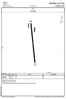
ADC chart of W10
 Satellite view of W10

Satellite view of W10
Sorry, we have no imagery here.
Sorry, we have no imagery here.
Sorry, we have no imagery here.
Sorry, we have no imagery here.
Sorry, we have no imagery here.
Sorry, we have no imagery here.


W10 - Whidbey Air Park
Located in Langley, United States
ICAO - W10, IATA -
Data provided by AirmateGeneral information
Coordinates: N48°1'3" W122°26'16"
Elevation is 271 feet MSL.
Magnetic variation is 21° East View others Airports in Washington
Operational data
Special qualification required
Current time UTC: 12:54:56
Current local time:
Weather at : KPAE - Seattle Paine Fld Intl ( 17 km )
METAR: KPAE 291244Z AUTO 16008KT 9SM -RA SCT020 SCT043 OVC085 13/11 A3004 RMK AO2 RAB15 P0001 T01280111 TSNO
TAF: KPAE 291122Z 2912/3012 18015G20KT P6SM -RA SCT015 OVC100 FM291300 17012G22KT P6SM -RA OVC020 FM291500 18010G18KT P6SM -SHRA OVC015 FM292100 35009KT P6SM OVC035 FM300300 01006KT P6SM SKC FM300900 35003KT P6SM BKN250
Communications frequencies: [VIEW]
Runways:
| RWY identifier | QFU | Length (ft) | Width (ft) | Surface | LDA (ft) |
| 16 | 0° | 2470 | 25 | ASPH | |
| 34 | 0° | 2470 | 25 | ASPH |
Airport contact information
Address: Langley United States
Satellite view of W10
Sorry, we have no imagery here.
Sorry, we have no imagery here.
Sorry, we have no imagery here.
Sorry, we have no imagery here.
Sorry, we have no imagery here.
Sorry, we have no imagery here.