ADC chart of W09
 Satellite view of W09

Satellite view of W09
Sorry, we have no imagery here.
Sorry, we have no imagery here.
Sorry, we have no imagery here.
Sorry, we have no imagery here.
Sorry, we have no imagery here.
Sorry, we have no imagery here.


W09 - Lower Monumental State
Located in Kahlotus, United States
ICAO - W09, IATA -
Data provided by AirmateGeneral information
Coordinates: N46°32'59" W118°32'12"
Elevation is 813 feet MSL.
Magnetic variation is 19° East View others Airports in Washington
Operational data
Special qualification required
Current time UTC: 10:30:41
Current local time:
Weather at : KALW - Walla Walla Rgnl ( 54 km )
METAR: KALW 290953Z AUTO 18009KT 10SM CLR 22/08 A2987 RMK AO2 SLP104 T02220083
TAF: KALW 290520Z 2906/3006 17006KT P6SM VCSH SCT150 FM291000 18011KT P6SM FEW250 FM291500 19015G23KT P6SM BKN250
Communications frequencies: [VIEW]
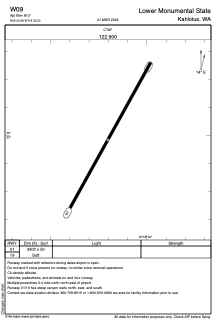
Runways:
| RWY identifier | QFU | Length (ft) | Width (ft) | Surface | LDA (ft) |
| 01 | 29° | 3300 | 50 | GRAVEL | |
| 19 | 209° | 3300 | 50 | GRAVEL |
Airport contact information
Address: Kahlotus United States
Satellite view of W09
Sorry, we have no imagery here.
Sorry, we have no imagery here.
Sorry, we have no imagery here.
Sorry, we have no imagery here.
Sorry, we have no imagery here.
Sorry, we have no imagery here.