ADC chart of W01
 Satellite view of W01

Satellite view of W01
Sorry, we have no imagery here.
Sorry, we have no imagery here.
Sorry, we have no imagery here.
Sorry, we have no imagery here.
Sorry, we have no imagery here.


W01 - Tonasket Muni
Located in Tonasket, United States
ICAO - W01, IATA -
Data provided by AirmateGeneral information
Coordinates: N48°43'30" W119°27'56"
Elevation is 1311 feet MSL.
Magnetic variation is 20° East View others Airports in Washington
Operational data
Special qualification required
Current time UTC: 12:06:44
Current local time:
Weather at : KOMK - Omak ( 29 km )
METAR: KOMK 301153Z AUTO 33006KT 10SM CLR 12/03 A3023 RMK AO2 SLP233 T01170028 10156 20100 53019
Communications frequencies: [VIEW]
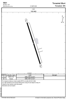
Runways:
| RWY identifier | QFU | Length (ft) | Width (ft) | Surface | LDA (ft) |
| 15 | 0° | 3053 | 50 | ASPH | |
| 33 | 0° | 3053 | 50 | ASPH |
Airport contact information
Address: Tonasket United States
Satellite view of W01
Sorry, we have no imagery here.
Sorry, we have no imagery here.
Sorry, we have no imagery here.
Sorry, we have no imagery here.
Sorry, we have no imagery here.