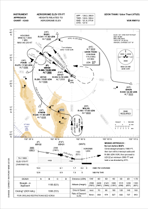
IAC chart of VTUD
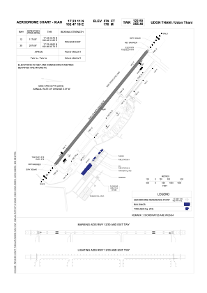
 ADC chart of VTUD
 Satellite view of VTUD

ADC chart of VTUD
Satellite view of VTUD
Sorry, we have no imagery here.
Sorry, we have no imagery here.
Sorry, we have no imagery here.
Sorry, we have no imagery here.
Sorry, we have no imagery here.
Sorry, we have no imagery here.


VTUD - Udon Thani / Udon Thani Airport
Located in Udon Thani, Thailand
ICAO - VTUD, IATA - UTH
Data provided by AirmateGeneral information
Coordinates: N17°23'11" E102°47'18"
Elevation is 579 feet MSL.
View others Airports in Udon Thani Province
Operational data
Special qualification required
Current time UTC: 06:40:02
Current local time:
Weather
METAR: VTUD 030600Z 16004KT 080V240 9999 SCT040 33/24 Q1009 NOSIG
Communications frequencies: [VIEW]
Runways:
| RWY identifier | QFU | Length (ft) | Width (ft) | Surface | LDA (ft) |
| 12 | 118° | 10000 | 148 | ASP | |
| 30 | 298° | 10000 | 148 | ASP |
Airport contact information
Address: Udon Thani Thailand
Satellite view of VTUD
Sorry, we have no imagery here.
Sorry, we have no imagery here.
Sorry, we have no imagery here.
Sorry, we have no imagery here.
Sorry, we have no imagery here.
Sorry, we have no imagery here.