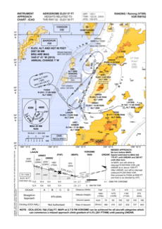
IAC chart of VTSR
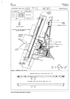
 ADC chart of VTSR
 Satellite view of VTSR
ADC chart of VTSR
Satellite view of VTSR
Sorry, we have no imagery here.
Sorry, we have no imagery here.
Sorry, we have no imagery here.
Sorry, we have no imagery here.
Sorry, we have no imagery here.
Sorry, we have no imagery here.


VTSR - Ranong / Ranong Airport
Located in Ranong, Thailand
ICAO - VTSR, IATA - UNN
Data provided by AirmateGeneral information
Coordinates: N9°46'39" E98°35'8"
Elevation is 57 feet MSL.
View others Airports in Ranong Province
Operational data
Special qualification required
Current time UTC: 11:25:50
Current local time:
Weather
METAR: VTSR 211100Z 16003KT 100V220 9999 SCT020 27/24 Q1007 NOSIG
TAF: TAF VTSR 210500Z 2106/2206 26005KT 9999 SCT020 TEMPO 2106/2114 -TSRA FEW018CB SCT020 BKN100
Communications frequencies: [VIEW]
Runways:
| RWY identifier | QFU | Length (ft) | Width (ft) | Surface | LDA (ft) |
| 02 | 24° | 6562 | 148 | CON | |
| 20 | 204° | 6562 | 148 | CON |
Airport contact information
Address: Ranong Thailand
Satellite view of VTSR
Sorry, we have no imagery here.
Sorry, we have no imagery here.
Sorry, we have no imagery here.
Sorry, we have no imagery here.
Sorry, we have no imagery here.
Sorry, we have no imagery here.