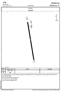
ADC chart of VT8
 Satellite view of VT8
Satellite view of VT8
Sorry, we have no imagery here.
Sorry, we have no imagery here.
Sorry, we have no imagery here.
Sorry, we have no imagery here.
Sorry, we have no imagery here.
Sorry, we have no imagery here.


VT8 - Shelburne
Located in Shelburne, United States
ICAO - VT8, IATA -
Data provided by AirmateGeneral information
Coordinates: N44°21'37" W73°13'35"
Elevation is 325 feet MSL.
Magnetic variation is -15° East View others Airports in Vermont
Operational data
Special qualification required
Current time UTC:
Current local time:
Weather at : KBTV - Patrick Leahy Burlington Intl ( 14 km )
METAR: KBTV 201454Z 35011KT 10SM OVC013 08/04 A3004 RMK AO2 SLP176 60000 T00780044 53005
TAF: KBTV 201329Z 2013/2112 35011KT P6SM SCT015 OVC020 FM202200 35006KT P6SM OVC015 FM210200 VRB03KT P6SM OVC025 FM210500 00000KT 4SM BR BKN040 FM211000 13004KT P6SM BKN025
Communications frequencies: [VIEW]
Runways:
| RWY identifier | QFU | Length (ft) | Width (ft) | Surface | LDA (ft) |
| 01 | 351° | 3077 | 60 | GRASS | |
| 19 | 171° | 3077 | 60 | GRASS |
Airport contact information
Address: Shelburne United States
