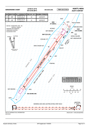
ADC chart of VOAT
 Satellite view of VOAT
Satellite view of VOAT
Sorry, we have no imagery here.
Sorry, we have no imagery here.
Sorry, we have no imagery here.
Sorry, we have no imagery here.
Sorry, we have no imagery here.
Sorry, we have no imagery here.


VOAT - Agatti Airport, Agatti
Located in Agatti, India
ICAO - VOAT, IATA - AGX
Data provided by AirmateGeneral information
Coordinates: N10°49'27" E72°10'36"
Elevation is 14 feet MSL.
View others Airports in Lakshadweep
Operational data
Special qualification required
Current time UTC: 01:31:37
Current local time:
Weather
METAR: VOAT 240100Z 24014KT 6000 SCT015 BKN080 29/26 Q1003
TAF: TAF VOAT 232300Z 2400/2409 23015G25KT 4000 -TSRA RA SCT012 FEW025CB BKN080
Communications frequencies: [VIEW]
Runways:
| RWY identifier | QFU | Length (ft) | Width (ft) | Surface | LDA (ft) |
| 04 | 35° | 3950 | 98 | ASP | |
| 22 | 215° | 3950 | 98 | ASP |
Airport contact information
Address: Agatti India
Satellite view of VOAT
Sorry, we have no imagery here.
Sorry, we have no imagery here.
Sorry, we have no imagery here.
Sorry, we have no imagery here.
Sorry, we have no imagery here.
Sorry, we have no imagery here.