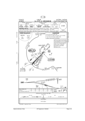
IAC chart of VIAG
 Satellite view of VIAG

Satellite view of VIAG
Sorry, we have no imagery here.
Sorry, we have no imagery here.
Sorry, we have no imagery here.
Sorry, we have no imagery here.
Sorry, we have no imagery here.
Sorry, we have no imagery here.


VIAG - Agra/Indian Air Force
Located in Agra, India
ICAO - VIAG, IATA - AGR
Data provided by AirmateGeneral information
Coordinates: N27°9'33" E77°57'38"
Elevation is 548 feet MSL.
View others Airports in Uttar Pradesh
Operational data
Special qualification required
Current time UTC: 19:08:42
Current local time:
Weather
TAF: TAF VIAG 231700Z 2318/2500 07008KT 6000 FEW030 TEMPO 2400/2402 5000 DU TEMPO 2407/2412 06020G30KT 3000 TSRA DU SCT025 FEW030CB BKN100 TEMPO 2330/2403 5000 DU HZ
Communications frequencies: [VIEW]
Runways:
| RWY identifier | QFU | Length (ft) | Width (ft) | Surface | LDA (ft) |
| 05 | 46° | 9404 | 148 | CON | |
| 23 | 226° | 9404 | 148 | CON | |
| 12 | 116° | 6001 | 148 | CON | |
| 30 | 296° | 6001 | 148 | CON |
Airport contact information
Address: Agra India
Satellite view of VIAG
Sorry, we have no imagery here.
Sorry, we have no imagery here.
Sorry, we have no imagery here.
Sorry, we have no imagery here.
Sorry, we have no imagery here.
Sorry, we have no imagery here.