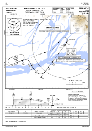
IAC chart of VETJ
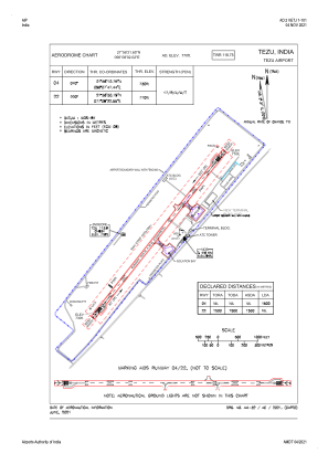
 ADC chart of VETJ
 Satellite view of VETJ

ADC chart of VETJ
Satellite view of VETJ
Sorry, we have no imagery here.
Sorry, we have no imagery here.
Sorry, we have no imagery here.
Sorry, we have no imagery here.
Sorry, we have no imagery here.
Sorry, we have no imagery here.


VETJ - Tezu Airport, Tezu
Located in Tezu, India
ICAO - , IATA - TEI
Data provided by AirmateGeneral information
Coordinates: N27°56'32" E96°8'2"
Elevation is 769 feet MSL.
View others Airports in Arunachal Pradesh
Operational data
Special qualification required
Current time UTC: 16:38:18
Current local time:
Weather at : - ( 0 km )
METAR: KY63 291635Z AUTO 35012KT 10SM CLR 21/07 A3016 RMK AO2 T02050068
Communications frequencies: [VIEW]
Runways:
| RWY identifier | QFU | Length (ft) | Width (ft) | Surface | LDA (ft) |
| 04 | 40° | 4921 | 98 | UNK | |
| 22 | 220° | 4921 | 98 | UNK |
Airport contact information
Address: Tezu India
Satellite view of VETJ
Sorry, we have no imagery here.
Sorry, we have no imagery here.
Sorry, we have no imagery here.
Sorry, we have no imagery here.
Sorry, we have no imagery here.
Sorry, we have no imagery here.