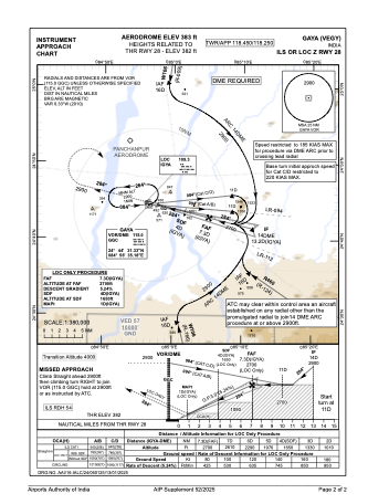
IAC chart of VEGY
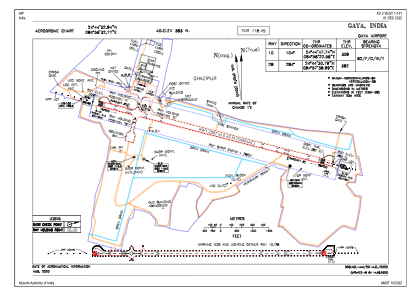
 ADC chart of VEGY
 Satellite view of VEGY

ADC chart of VEGY
Satellite view of VEGY
Sorry, we have no imagery here.
Sorry, we have no imagery here.
Sorry, we have no imagery here.
Sorry, we have no imagery here.
Sorry, we have no imagery here.
Sorry, we have no imagery here.


VEGY - Gaya Airport, Gaya
Located in Gaya, India
ICAO - VEGY, IATA - GAY
Data provided by AirmateGeneral information
Coordinates: N24°44'53" E84°56'33"
Elevation is 380 feet MSL.
View others Airports in Bihar
Operational data
Special qualification required
Current time UTC: 08:26:29
Current local time:
Weather
METAR: VEGY 240800Z 03008KT 5000 HZ SCT018 35/23 Q1001 NOSIG
TAF: TAF VEGY 240800Z 2409/2418 05010KT 5000 -RA HZ SCT018 BKN100 TEMPO 2410/2412 2500 -TSRA SCT018 FEW030CB BKN100 BECMG 2414/2416 3000 -RA BR
Communications frequencies: [VIEW]
Runways:
| RWY identifier | QFU | Length (ft) | Width (ft) | Surface | LDA (ft) |
| 10 | 104° | 7503 | 148 | ASP | |
| 28 | 284° | 7503 | 148 | ASP |
Airport contact information
Address: Gaya India
Satellite view of VEGY
Sorry, we have no imagery here.
Sorry, we have no imagery here.
Sorry, we have no imagery here.
Sorry, we have no imagery here.
Sorry, we have no imagery here.
Sorry, we have no imagery here.