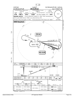
IAC chart of VEGK
 Satellite view of VEGK

Satellite view of VEGK
Sorry, we have no imagery here.
Sorry, we have no imagery here.
Sorry, we have no imagery here.
Sorry, we have no imagery here.
Sorry, we have no imagery here.
Sorry, we have no imagery here.


VEGK - Gorakhpur/Indian Air Force
Located in Gorakhpur, India
ICAO - VEGK, IATA - GOP
Data provided by AirmateGeneral information
Coordinates: N26°44'29" E83°27'1"
Elevation is 259 feet MSL.
View others Airports in Uttar Pradesh
Operational data
Special qualification required
Current time UTC: 00:50:19
Current local time:
Weather
TAF: VEGK 251530Z 2600/2612 12008KT 6000 SCT025 SCT090 BKN250 TEMPO 2600/2603 5000 HZ NSC TEMPO 2608/2611 35015G25KT SCT025 FEW030CB BKN090
Communications frequencies: [VIEW]
Runways:
| RWY identifier | QFU | Length (ft) | Width (ft) | Surface | LDA (ft) |
| 11 | 113° | 9111 | 148 | PEM | |
| 29 | 293° | 9111 | 148 | PEM |
Airport contact information
Address: Gorakhpur India
Satellite view of VEGK
Sorry, we have no imagery here.
Sorry, we have no imagery here.
Sorry, we have no imagery here.
Sorry, we have no imagery here.
Sorry, we have no imagery here.
Sorry, we have no imagery here.