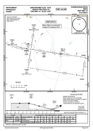
IAC chart of VEDH
 Satellite view of VEDH

Satellite view of VEDH
Sorry, we have no imagery here.
Sorry, we have no imagery here.
Sorry, we have no imagery here.
Sorry, we have no imagery here.
Sorry, we have no imagery here.
Sorry, we have no imagery here.


VEDH - Darbhanga
Located in DARBHANGA, India
ICAO - , IATA - DBR
Data provided by AirmateGeneral information
Coordinates: N26°11'39" E85°54'55"
Elevation is 154 feet MSL.
View others Airports in Bihar
Operational data
Special qualification required
Current time UTC: 05:24:23
Current local time:
Weather at : - ( 0 km )
METAR: YLHI 190522Z AUTO 11015G25KT 8000 // BKN013 BKN017 OVC023 20/17 Q1016
Communications frequencies: [VIEW]
Runways:
| RWY identifier | QFU | Length (ft) | Width (ft) | Surface | LDA (ft) |
| 10 | 0° | 8999 | 150 | UNK | |
| 28 | 0° | 8999 | 150 | UNK |
Airport contact information
Address: DARBHANGA India
Satellite view of VEDH
Sorry, we have no imagery here.
Sorry, we have no imagery here.
Sorry, we have no imagery here.
Sorry, we have no imagery here.
Sorry, we have no imagery here.
Sorry, we have no imagery here.