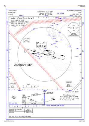
IAC chart of VAPR
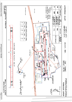
 ADC chart of VAPR
 Satellite view of VAPR

ADC chart of VAPR
Satellite view of VAPR
Sorry, we have no imagery here.
Sorry, we have no imagery here.
Sorry, we have no imagery here.
Sorry, we have no imagery here.
Sorry, we have no imagery here.
Sorry, we have no imagery here.


VAPR - Porbandar Airport, Porbandar
Located in Porbandar, India
ICAO - VAPR, IATA - PBD
Data provided by AirmateGeneral information
Coordinates: N21°39'1" E69°39'31"
Elevation is 23 feet MSL.
View others Airports in Gujarat
Operational data
Special qualification required
Current time UTC: 14:56:05
Current local time:
Weather
METAR: VAPR 191400Z 28006KT 5000 FU FEW025 SCT025 30/25 Q1004 NOSIG
Communications frequencies: [VIEW]
Runways:
| RWY identifier | QFU | Length (ft) | Width (ft) | Surface | LDA (ft) |
| 09 | 88° | 4498 | 148 | ASP | |
| 27 | 268° | 4498 | 148 | ASP |
Airport contact information
Address: Porbandar India
Satellite view of VAPR
Sorry, we have no imagery here.
Sorry, we have no imagery here.
Sorry, we have no imagery here.
Sorry, we have no imagery here.
Sorry, we have no imagery here.
Sorry, we have no imagery here.