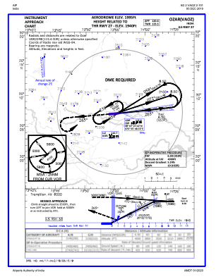
IAC chart of VAOZ
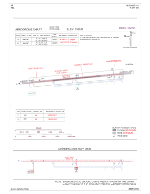
 ADC chart of VAOZ
 Satellite view of VAOZ

ADC chart of VAOZ
Satellite view of VAOZ
Sorry, we have no imagery here.
Sorry, we have no imagery here.
Sorry, we have no imagery here.
Sorry, we have no imagery here.
Sorry, we have no imagery here.
Sorry, we have no imagery here.


VAOZ - Ozar Airport
Located in Ozar, India
ICAO - VAOZ, IATA - ISK
Data provided by AirmateGeneral information
Coordinates: N20°7'12" E73°54'48"
Elevation is 1995 feet MSL.
View others Airports in Maharashtra
Operational data
Special qualification required
Current time UTC: 06:33:15
Current local time:
Weather
METAR: VAOZ 230600Z 07005KT 6000 SCT030 BKN090 29/29 Q1005 NOSIG
Communications frequencies: [VIEW]
Runways:
| RWY identifier | QFU | Length (ft) | Width (ft) | Surface | LDA (ft) |
| 09 | 84° | 9843 | 148 | PEM | |
| 27 | 264° | 9843 | 148 | PEM |
Airport contact information
Address: Ozar India
Satellite view of VAOZ
Sorry, we have no imagery here.
Sorry, we have no imagery here.
Sorry, we have no imagery here.
Sorry, we have no imagery here.
Sorry, we have no imagery here.
Sorry, we have no imagery here.