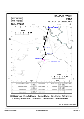
VAC chart of VANP
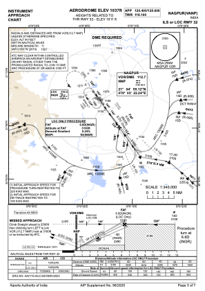
 IAC chart of VANP
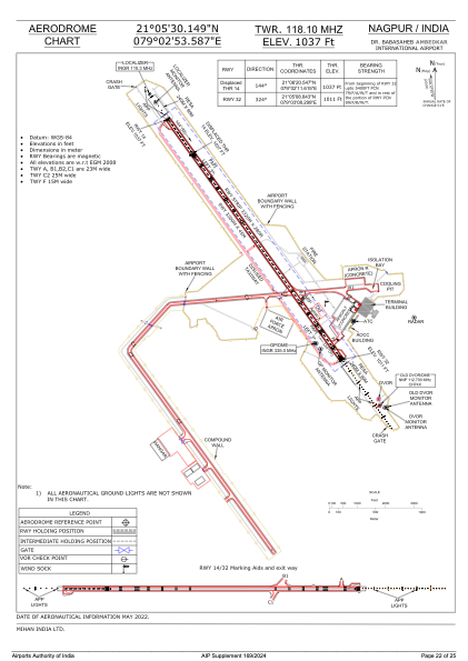
 ADC chart of VANP
 Satellite view of VANP

IAC chart of VANPADC chart of VANP
Satellite view of VANP
Sorry, we have no imagery here.
Sorry, we have no imagery here.
Sorry, we have no imagery here.
Sorry, we have no imagery here.
Sorry, we have no imagery here.
Sorry, we have no imagery here.


VANP - Dr Babasaheb Ambedkar International Airport , Nagpur
Located in Nagpur, India
ICAO - VANP, IATA - NAG
Data provided by AirmateGeneral information
Coordinates: N21°5'30" E79°2'54"
Elevation is 1033 feet MSL.
View others Airports in Maharashtra
Operational data
Special qualification required
Current time UTC: 14:02:20
Current local time:
Weather
METAR: VANP 251330Z 03003KT 5000 HZ SCT020 FEW030CB BKN090 33/22 Q1002 NOSIG
TAF: TAF VANP 251100Z 2512/2618 07007KT 5000 HZ SCT020 SCT090 TEMPO 2512/2516 VRB10G20KT 3000 -TSRA SCT020 FEW030CB SCT090 BECMG 2516/2518 05005KT 4000 -RA/BR/HZ SCT020 SCT090 BECMG 2601/2603 36005KT 3000 BR/HZ SCT100 BECMG 2603/2605 05005KT 5000 HZ SCT020 TEMPO 2612/2616 VRB10G20KT 3000 -TSRA SCT020 FEW030CB SCT090 BECMG 2616/2618 VRB03KT 4000 HZ SCT020 SCT090
Communications frequencies: [VIEW]
Runways:
| RWY identifier | QFU | Length (ft) | Width (ft) | Surface | LDA (ft) |
| 14 | 144° | 10499 | 148 | ASP | |
| 32 | 324° | 10499 | 148 | ASP |
Airport contact information
Address: Nagpur India
Satellite view of VANP
Sorry, we have no imagery here.
Sorry, we have no imagery here.
Sorry, we have no imagery here.
Sorry, we have no imagery here.
Sorry, we have no imagery here.
Sorry, we have no imagery here.