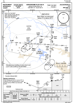
IAC chart of VAJL
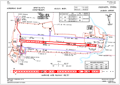
 ADC chart of VAJL
 Satellite view of VAJL

ADC chart of VAJL
Satellite view of VAJL
Sorry, we have no imagery here.
Sorry, we have no imagery here.
Sorry, we have no imagery here.
Sorry, we have no imagery here.
Sorry, we have no imagery here.
Sorry, we have no imagery here.


VAJL - Jalgaon Airport, Jalgaon
Located in Jalgaon, India
ICAO - , IATA -
Data provided by AirmateGeneral information
Coordinates: N20°57'41" E75°37'29"
Elevation is 842 feet MSL.
View others Airports in Maharashtra
Operational data
Special qualification required
Current time UTC: 11:37:01
Current local time:
Weather at : - ( 0 km )
METAR: PPIZ 251133Z AUTO 09005KT 5SM BR BKN002 OVC011 M06/M07 A2976 RMK AO2 FZRANO
Communications frequencies: [VIEW]
Runways:
| RWY identifier | QFU | Length (ft) | Width (ft) | Surface | LDA (ft) |
| 09 | 94° | 5577 | 148 | UNK | |
| 27 | 274° | 5577 | 148 | UNK |
Airport contact information
Address: Jalgaon India
Satellite view of VAJL
Sorry, we have no imagery here.
Sorry, we have no imagery here.
Sorry, we have no imagery here.
Sorry, we have no imagery here.
Sorry, we have no imagery here.
Sorry, we have no imagery here.