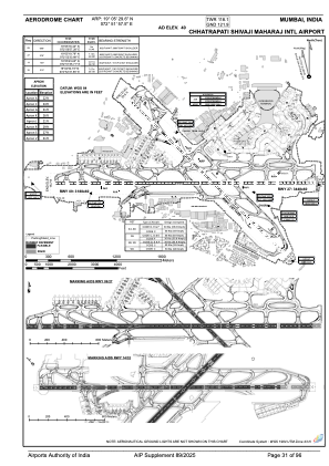
ADC chart of VABB
 Satellite view of VABB

Satellite view of VABB
Sorry, we have no imagery here.
Sorry, we have no imagery here.
Sorry, we have no imagery here.
Sorry, we have no imagery here.
Sorry, we have no imagery here.
Sorry, we have no imagery here.


VABB - Chhatrapati Shivaji Maharaj International Airport, Mumbai
Located in Mumbai, India
ICAO - VABB, IATA - BOM
Data provided by AirmateGeneral information
Coordinates: N19°5'30" E72°51'58"
Elevation is 40 feet MSL.
View others Airports in Maharashtra
Operational data
Special qualification required
Current time UTC: 19:12:12
Current local time:
Weather
METAR: VABB 221830Z 00000KT 3000 HZ FEW020 SCT025 29/25 Q1001 NOSIG
TAF: TAF VABB 221700Z 2218/2324 23007KT 3000 -DZ HZ SCT018 FEW025TCU BKN090 TEMPO 2218/2221 2000 TSRA SHRA SCT018 FEW030TCU CB BKN090 BECMG 2221/2223 VRB03KT 2500 -DZ BR BECMG 2303/2305 05005KT 3000 -DZ HZ SCT018 SCT025 BKN100 BECMG 2308/2310 02010KT 4000 HZ FEW020 FEW025TCU SCT090 TEMPO 2312/2318 32007G17KT 2000 TSRA SHRA FEW018 FEW030TCU CB BKN100 BECMG 2315/2317 09005KT 3000 BR HZ SCT020 SCT100 BECMG 2321/2323 VRB03KT 2500 BR HZ
Communications frequencies: [VIEW]
Runways:
| RWY identifier | QFU | Length (ft) | Width (ft) | Surface | LDA (ft) |
| 14 | 135° | 9419 | 148 | ASP | |
| 32 | 315° | 9419 | 148 | ASP | |
| 09 | 90° | 11312 | 197 | ASP | |
| 27 | 270° | 11312 | 197 | ASP |
Airport contact information
Address: Mumbai India
Satellite view of VABB
Sorry, we have no imagery here.
Sorry, we have no imagery here.
Sorry, we have no imagery here.
Sorry, we have no imagery here.
Sorry, we have no imagery here.
Sorry, we have no imagery here.