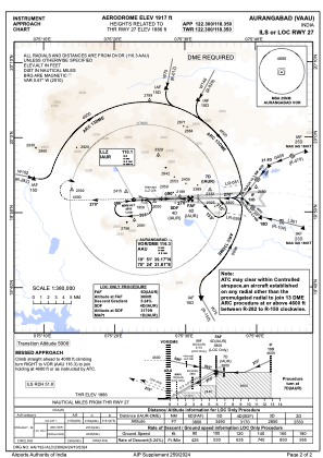
IAC chart of VAAU
 ADC chart of VAAU
 Satellite view of VAAU
ADC chart of VAAU
Satellite view of VAAU
Sorry, we have no imagery here.
Sorry, we have no imagery here.
Sorry, we have no imagery here.
Sorry, we have no imagery here.
Sorry, we have no imagery here.
Sorry, we have no imagery here.


VAAU - Aurangabad Airport, Aurangabad
Located in Aurangabad, India
ICAO - VAAU, IATA - IXU
Data provided by AirmateGeneral information
Coordinates: N19°51'52" E75°23'51"
Elevation is 1917 feet MSL.
View others Airports in Maharashtra
Operational data
Special qualification required
Current time UTC: 13:18:06
Current local time:
Weather
METAR: VAAU 241300Z 02005KT 4000 HZ SCT020 SCT025 BKN100 29/22 Q1002 BECMG 3000 HZ
TAF: TAF VAAU 240500Z 2406/2415 07010KT 4000 HZ FEW020 SCT025 BKN100 TEMPO 2409/2415 07007G17KT 2000 -TSRA -SHRA SCT020 FEW030CB OVC080
Communications frequencies: [VIEW]
Runways:
| RWY identifier | QFU | Length (ft) | Width (ft) | Surface | LDA (ft) |
| 09 | 89° | 9314 | 148 | PEM | |
| 27 | 269° | 9314 | 148 | PEM |
Airport contact information
Address: Aurangabad India
Satellite view of VAAU
Sorry, we have no imagery here.
Sorry, we have no imagery here.
Sorry, we have no imagery here.
Sorry, we have no imagery here.
Sorry, we have no imagery here.
Sorry, we have no imagery here.