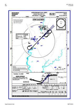
IAC chart of VAAH
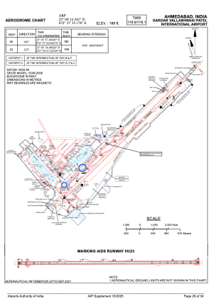
 ADC chart of VAAH
 Satellite view of VAAH

ADC chart of VAAH
Satellite view of VAAH
Sorry, we have no imagery here.
Sorry, we have no imagery here.
Sorry, we have no imagery here.
Sorry, we have no imagery here.
Sorry, we have no imagery here.
Sorry, we have no imagery here.


VAAH - Sardar Vallabhbhai Patel International Airport, Ahmedabad
Located in Ahmedabad, India
ICAO - VAAH, IATA - AMD
Data provided by AirmateGeneral information
Coordinates: N23°4'16" E72°37'35"
Elevation is 189 feet MSL.
View others Airports in Gujarat
Operational data
Special qualification required
Current time UTC: 23:59:39
Current local time:
Weather
METAR: VAAH 192330Z 10005KT 4000 FU NSC 30/21 Q1003 NOSIG
TAF: TAF VAAH 192300Z 2000/2106 14008KT 4000 HZ FU FEW080 BECMG 2001/2003 16008KT 3000 BR HZ SCT020 BECMG 2004/2006 18008KT 4000 HZ FU FEW020 SCT080 TEMPO 2005/2009 23010G20KT 3000 -TSRA -RA FEW015 SCT020 FEW030CB BKN080 BECMG 2007/2009 20006KT 5000 FU BECMG 2012/2014 20008KT 4000 TS SCT020 SCT080 FEW030CB TEMPO 2010/2016 25010G20KT 1500 -TSRA -RA FEW012 SCT018 FEW030CB BKN080 BECMG 2020/2022 16008KT BECMG 2101/2103 20006KT 3000 BR HZ SCT020 SCT080 BECMG 2104/2106 23008KT 4000 HZ FU
Communications frequencies: [VIEW]
Runways:
| RWY identifier | QFU | Length (ft) | Width (ft) | Surface | LDA (ft) |
| 05 | 45° | 11499 | 148 | PEM | |
| 23 | 225° | 11499 | 148 | PEM |
Airport contact information
Address: Ahmedabad India
Satellite view of VAAH
Sorry, we have no imagery here.
Sorry, we have no imagery here.
Sorry, we have no imagery here.
Sorry, we have no imagery here.
Sorry, we have no imagery here.
Sorry, we have no imagery here.