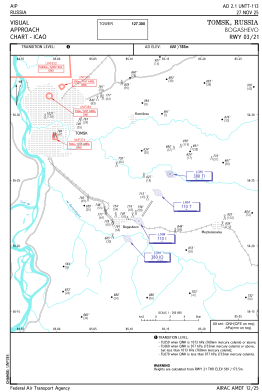
VAC chart of UNTT
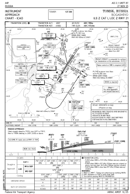
 IAC chart of UNTT
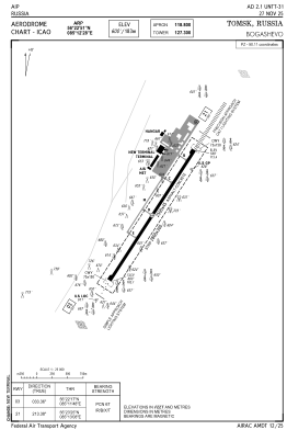
 ADC chart of UNTT
 Satellite view of UNTT

IAC chart of UNTTADC chart of UNTT
Satellite view of UNTT
Sorry, we have no imagery here.
Sorry, we have no imagery here.
Sorry, we have no imagery here.
Sorry, we have no imagery here.
Sorry, we have no imagery here.
Sorry, we have no imagery here.


UNTT - Tomsk/Bogashevo
Located in Tomsk, Russian Federation
ICAO - UNTT, IATA - TOF
Data provided by AirmateGeneral information
Coordinates: N56°22'51" E85°12'28"
Elevation is 600 feet MSL.
View others Airports in Tomsk Oblast
Operational data
Special qualification required
Current time UTC: 05:00:27
Current local time:
Weather
METAR: UNTT 260430Z 27005MPS CAVOK 11/M03 Q1006 R21/090060 NOSIG RMK QFE739
TAF: TAF UNTT 260200Z 2603/2612 33003G08MPS 8000 -SHRA BKN016CB BECMG 2604/2607 30005G13MPS
Communications frequencies: [VIEW]
Runways:
| RWY identifier | QFU | Length (ft) | Width (ft) | Surface | LDA (ft) |
| 03 | 33° | 8202 | 148 | UNK | |
| 21 | 213° | 8202 | 148 | UNK |
Airport contact information
Address: Tomsk Russian Federation
Satellite view of UNTT
Sorry, we have no imagery here.
Sorry, we have no imagery here.
Sorry, we have no imagery here.
Sorry, we have no imagery here.
Sorry, we have no imagery here.
Sorry, we have no imagery here.