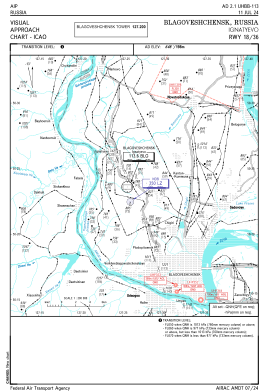
VAC chart of UHBB
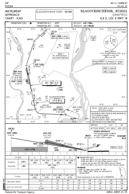
 IAC chart of UHBB
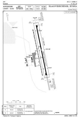
 ADC chart of UHBB
 Satellite view of UHBB

IAC chart of UHBBADC chart of UHBB
Satellite view of UHBB
Sorry, we have no imagery here.
Sorry, we have no imagery here.
Sorry, we have no imagery here.
Sorry, we have no imagery here.
Sorry, we have no imagery here.
Sorry, we have no imagery here.


UHBB - Blagoveshchensk/Ignatyevo
Located in Blagoveshchensk, Russian Federation
ICAO - UHBB, IATA - BQS
Data provided by AirmateGeneral information
Coordinates: N50°25'37" E127°24'56"
Elevation is 648 feet MSL.
View others Airports in Amur Oblast
Operational data
Special qualification required
Current time UTC: 19:46:06
Current local time:
Weather
METAR: UHBB 291900Z 22003MPS 9999 FEW033 18/12 Q1005 R18/090063 NOSIG RMK QFE739/0985
TAF: TAF UHBB 291642Z 2918/3018 22003MPS 9999 SCT033CB TX32/3007Z BECMG 3002/3005 18007G14MPS BECMG 3014/3016 25003MPS
Communications frequencies: [VIEW]
Runways:
| RWY identifier | QFU | Length (ft) | Width (ft) | Surface | LDA (ft) |
| 18 | 168° | 9843 | 148 | ASP | |
| 36 | 348° | 9843 | 148 | ASP |
Airport contact information
Address: Blagoveshchensk Russian Federation
Satellite view of UHBB
Sorry, we have no imagery here.
Sorry, we have no imagery here.
Sorry, we have no imagery here.
Sorry, we have no imagery here.
Sorry, we have no imagery here.
Sorry, we have no imagery here.