IAC chart of SVST
 ADC chart of SVST
 Satellite view of SVST

ADC chart of SVST
Satellite view of SVST
Sorry, we have no imagery here.
Sorry, we have no imagery here.
Sorry, we have no imagery here.
Sorry, we have no imagery here.
Sorry, we have no imagery here.
Sorry, we have no imagery here.


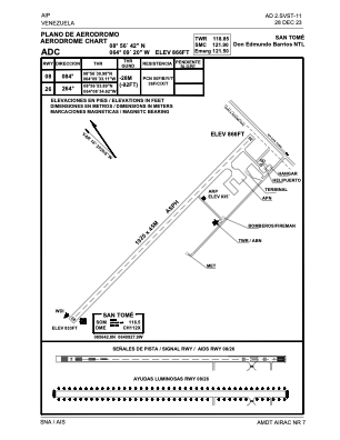
SVST - San Tome / Don Edmundo Barrios Ntl
Located in San Tome, Venezuela
ICAO - SVST, IATA - SOM
Data provided by AirmateGeneral information
Coordinates: N8°56'42" W64°9'3"
Elevation is 866 feet MSL.
Magnetic variation is -14° East View others Airports in Anzoategui
Operational data
Special qualification required
Current time UTC: 09:09:01
Current local time:
Weather at : - ( 0 km )
METAR: URRP 250906Z 13010G15MPS CAVOK 29/05 Q1017 R05/CLRD70 NOSIG RMK QFE757/1010
Communications frequencies: [VIEW]
Runways:
| RWY identifier | QFU | Length (ft) | Width (ft) | Surface | LDA (ft) |
| 08 | 68° | 6302 | 150 | ASPH | 6299 |
| 26 | 248° | 6302 | 150 | ASPH | 6299 |
Airport contact information
Address: San Tome Venezuela
Satellite view of SVST
Sorry, we have no imagery here.
Sorry, we have no imagery here.
Sorry, we have no imagery here.
Sorry, we have no imagery here.
Sorry, we have no imagery here.
Sorry, we have no imagery here.