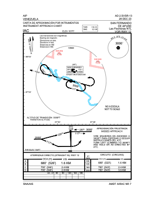
IAC chart of SVSR
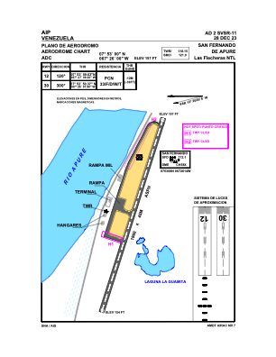
 ADC chart of SVSR
 Satellite view of SVSR

ADC chart of SVSR
Satellite view of SVSR
Sorry, we have no imagery here.
Sorry, we have no imagery here.
Sorry, we have no imagery here.
Sorry, we have no imagery here.
Sorry, we have no imagery here.
Sorry, we have no imagery here.


SVSR - San Fernando De Apure / Las Flecheras Ntl
Located in San Fernando De Apure, Venezuela
ICAO - SVSR, IATA - SFD
Data provided by AirmateGeneral information
Coordinates: N7°52'59" W67°26'37"
Elevation is 157 feet MSL.
Magnetic variation is -12° East View others Airports in Apure
Operational data
Special qualification required
Current time UTC: 07:49:19
Current local time:
Weather at : - ( 0 km )
METAR: MMML 290745Z 06004KT 10SM SKC 22/13 A2980
Communications frequencies: [VIEW]
Runways:
| RWY identifier | QFU | Length (ft) | Width (ft) | Surface | LDA (ft) |
| 12 | 108° | 6378 | 150 | ASPH | 6430 |
| 30 | 288° | 6378 | 150 | ASPH | 6430 |
Airport contact information
Address: San Fernando De Apure Venezuela
Satellite view of SVSR
Sorry, we have no imagery here.
Sorry, we have no imagery here.
Sorry, we have no imagery here.
Sorry, we have no imagery here.
Sorry, we have no imagery here.
Sorry, we have no imagery here.