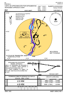
IAC chart of SVPA
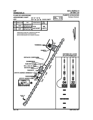
 ADC chart of SVPA
 Satellite view of SVPA

ADC chart of SVPA
Satellite view of SVPA
Sorry, we have no imagery here.
Sorry, we have no imagery here.
Sorry, we have no imagery here.
Sorry, we have no imagery here.
Sorry, we have no imagery here.
Sorry, we have no imagery here.


SVPA - Puerto Ayacucho / Cacique Aramare Ntl
Located in Puerto Ayacucho, Venezuela
ICAO - SVPA, IATA - PYH
Data provided by AirmateGeneral information
Coordinates: N5°37'12" W67°36'22"
Elevation is 236 feet MSL.
Magnetic variation is -12° East View others Airports in Amazonas
Operational data
Special qualification required
Current time UTC: 20:42:26
Current local time:
Weather at : SKPC - Puerto Carreno-German Olano ( 64 km )
METAR: SKPC 292000Z 01004KT 310V120 9999 FEW027 34/23 Q1010
Communications frequencies: [VIEW]
Runways:
| RWY identifier | QFU | Length (ft) | Width (ft) | Surface | LDA (ft) |
| 04 | 30° | 8307 | 138 | ASPH | 8268 |
| 22 | 210° | 8307 | 138 | ASPH | 8268 |
Airport contact information
Address: Puerto Ayacucho Venezuela
Satellite view of SVPA
Sorry, we have no imagery here.
Sorry, we have no imagery here.
Sorry, we have no imagery here.
Sorry, we have no imagery here.
Sorry, we have no imagery here.
Sorry, we have no imagery here.