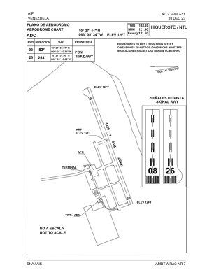
ADC chart of SVHG
 Satellite view of SVHG
Satellite view of SVHG
Sorry, we have no imagery here.
Sorry, we have no imagery here.
Sorry, we have no imagery here.
Sorry, we have no imagery here.
Sorry, we have no imagery here.
Sorry, we have no imagery here.


SVHG - Higuerote
Located in Higuerote, Venezuela
ICAO - SVHG, IATA - HGE
Data provided by AirmateGeneral information
Coordinates: N10°27'45" W66°5'33"
Elevation is 12 feet MSL.
Magnetic variation is -13° East View others Airports in Miranda
Operational data
Special qualification required
Current time UTC: 18:19:06
Current local time:
Weather at : - ( 0 km )
METAR: KDOV 281817Z AUTO 10011G18KT 2 1/4SM -RA BR BKN006 OVC012 15/14 A3017 RMK AO2 VIS 2 1/4V4 CIG 004V006 SLP220
Communications frequencies: [VIEW]
Runways:
| RWY identifier | QFU | Length (ft) | Width (ft) | Surface | LDA (ft) |
| 08 | 70° | 3907 | 126 | ASPH | 3937 |
| 26 | 250° | 3907 | 126 | ASPH | 3937 |
Airport contact information
Address: Higuerote Venezuela
Satellite view of SVHG
Sorry, we have no imagery here.
Sorry, we have no imagery here.
Sorry, we have no imagery here.
Sorry, we have no imagery here.
Sorry, we have no imagery here.
Sorry, we have no imagery here.