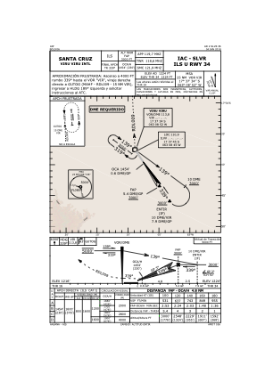
IAC chart of SLVR
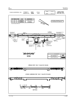
 ADC chart of SLVR
 Satellite view of SLVR

ADC chart of SLVR
Satellite view of SLVR
Sorry, we have no imagery here.
Sorry, we have no imagery here.
Sorry, we have no imagery here.
Sorry, we have no imagery here.
Sorry, we have no imagery here.
Sorry, we have no imagery here.


SLVR - Viru Viru/Intl
Located in Santa Cruz De La Sierra, Bolivia
ICAO - SLVR, IATA - VVI
Data provided by AirmateGeneral information
Coordinates: S17°38'46" W63°8'16"
Elevation is 1224 feet MSL.
View others Airports in Santa Cruz
Operational data
Special qualification required
Current time UTC: 06:54:19
Current local time:
Weather
METAR: SLVR 210600Z 19008KT 9999 FEW017 BKN070 20/19 Q1016
TAF: TAF SLVR 210410Z 2106/2206 18010KT 9999 BKN017 BKN070 TX28/2119Z TN18/2110Z TEMPO 2109/2113 BKN010 BECMG 2118/2121 03006KT BKN025 BECMG 2200/2203 VRB02KT SCT070
Communications frequencies: [VIEW]
Runways:
| RWY identifier | QFU | Length (ft) | Width (ft) | Surface | LDA (ft) |
| 16 | 147° | 11483 | 148 | CON | |
| 34 | 327° | 11483 | 148 | CON |
Airport contact information
Address: Santa Cruz De La Sierra Bolivia
Satellite view of SLVR
Sorry, we have no imagery here.
Sorry, we have no imagery here.
Sorry, we have no imagery here.
Sorry, we have no imagery here.
Sorry, we have no imagery here.
Sorry, we have no imagery here.