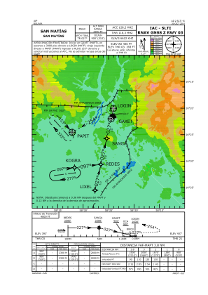
IAC chart of SLTI
 Satellite view of SLTI

Satellite view of SLTI
Sorry, we have no imagery here.
Sorry, we have no imagery here.
Sorry, we have no imagery here.
Sorry, we have no imagery here.
Sorry, we have no imagery here.
Sorry, we have no imagery here.


SLTI - San Matias
Located in San Matias, Bolivia
ICAO - SLTI, IATA - MQK
Data provided by AirmateGeneral information
Coordinates: S16°20'22" W58°24'5"
Elevation is 407 feet MSL.
View others Airports in Santa Cruz
Operational data
Special qualification required
Current time UTC: 15:25:47
Current local time:
Weather at : - ( 0 km )
METAR: KAFP 221521Z AUTO 26005KT 10SM CLR 26/09 A2990 RMK AO2 T02550090
Communications frequencies: [VIEW]
Runways:
| RWY identifier | QFU | Length (ft) | Width (ft) | Surface | LDA (ft) |
| 03 | 13° | 6234 | 98 | UNK | |
| 21 | 193° | 6234 | 98 | UNK |
Airport contact information
Address: San Matias Bolivia
Satellite view of SLTI
Sorry, we have no imagery here.
Sorry, we have no imagery here.
Sorry, we have no imagery here.
Sorry, we have no imagery here.
Sorry, we have no imagery here.
Sorry, we have no imagery here.