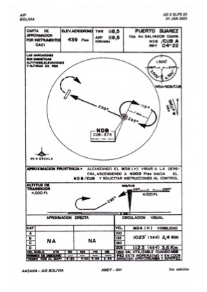
IAC chart of SLPS
 Satellite view of SLPS

Satellite view of SLPS
Sorry, we have no imagery here.
Sorry, we have no imagery here.
Sorry, we have no imagery here.
Sorry, we have no imagery here.
Sorry, we have no imagery here.
Sorry, we have no imagery here.


SLPS - Tte. Av. Salvador Ogaya G.
Located in Puerto Suarez, Bolivia
ICAO - SLPS, IATA - PSZ
Data provided by AirmateGeneral information
Coordinates: S18°58'32" W57°49'12"
Elevation is 440 feet MSL.
View others Airports in Santa Cruz
Operational data
Special qualification required
Current time UTC: 04:28:10
Current local time:
Communications frequencies: [VIEW]
Runways:
| RWY identifier | QFU | Length (ft) | Width (ft) | Surface | LDA (ft) |
| 05 | 32° | 6562 | 118 | UNK | |
| 23 | 212° | 6562 | 118 | UNK |
Airport contact information
Address: Puerto Suarez Bolivia
Satellite view of SLPS
Sorry, we have no imagery here.
Sorry, we have no imagery here.
Sorry, we have no imagery here.
Sorry, we have no imagery here.
Sorry, we have no imagery here.
Sorry, we have no imagery here.