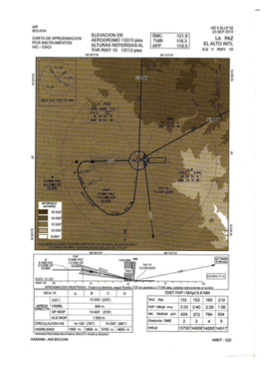
IAC chart of SLLP
 ADC chart of SLLP
 Satellite view of SLLP

ADC chart of SLLP
Satellite view of SLLP
Sorry, we have no imagery here.
Sorry, we have no imagery here.
Sorry, we have no imagery here.
Sorry, we have no imagery here.
Sorry, we have no imagery here.
Sorry, we have no imagery here.


SLLP - El Alto/ Intl
Located in La Paz, Bolivia
ICAO - SLLP, IATA - LPB
Data provided by AirmateGeneral information
Coordinates: S16°30'45" W68°11'32"
Elevation is 13314 feet MSL.
View others Airports in La Paz
Operational data
Special qualification required
Current time UTC: 07:53:41
Current local time:
Weather
METAR: SLLP 220733Z VRB02KT 6000 3000E VCFG FEW002 SCT200 00/M01 Q1038
TAF: TAF SLLP 220400Z 2206/2306 08006KT 4000 BCFG FEW002 BKN010 TX14/2219Z TNM02/2210Z BECMG 2213/2215 24010KT 9999 NSW FEW015 BECMG 2223/2302 08006KT
Communications frequencies: [VIEW]
Runways:
| RWY identifier | QFU | Length (ft) | Width (ft) | Surface | LDA (ft) |
| 10 | 91° | 13124 | 151 | CON | |
| 28 | 272° | 13124 | 151 | CON |
Airport contact information
Address: La Paz Bolivia
Satellite view of SLLP
Sorry, we have no imagery here.
Sorry, we have no imagery here.
Sorry, we have no imagery here.
Sorry, we have no imagery here.
Sorry, we have no imagery here.
Sorry, we have no imagery here.