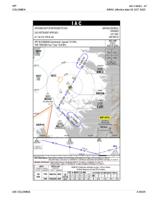
IAC chart of SKEJ
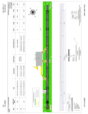
 ADC chart of SKEJ
 Satellite view of SKEJ

ADC chart of SKEJ
Satellite view of SKEJ
Sorry, we have no imagery here.
Sorry, we have no imagery here.
Sorry, we have no imagery here.
Sorry, we have no imagery here.
Sorry, we have no imagery here.


SKEJ - Yariguies
Located in Barrancabermeja, Colombia
ICAO - SKEJ, IATA - EJA
Data provided by AirmateGeneral information
Coordinates: N7°1'26" W73°48'26"
Elevation is 414 feet MSL.
Magnetic variation is -8° East View others Airports in Santander
Operational data
Special qualification required
Current time UTC: 16:13:15
Current local time:
Weather at : SKBG - Palonegro ( 70 km )
METAR: SKBG 301600Z 34006KT 300V040 9999 SCT015 SCT040 28/21 Q1016
TAF: TAF SKBG 301055Z 3012/3112 VRB03KT 9999 SCT020 PROB40 TEMPO 3012/3014 4000 BCFG SCT010 TEMPO 3021/3101 TSRA BKN030CB TX29/3019Z TN20/3110Z
Communications frequencies: [VIEW]
Runways:
| RWY identifier | QFU | Length (ft) | Width (ft) | Surface | LDA (ft) |
| 04 | 31° | 5906 | 148 | ASPH | 5906 |
| 22 | 211° | 5906 | 148 | ASPH | 5906 |
Airport contact information
Address: Barrancabermeja Colombia
Satellite view of SKEJ
Sorry, we have no imagery here.
Sorry, we have no imagery here.
Sorry, we have no imagery here.
Sorry, we have no imagery here.
Sorry, we have no imagery here.