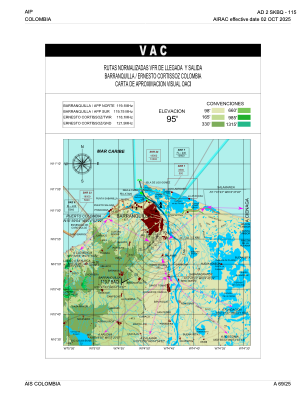
VAC chart of SKBQ
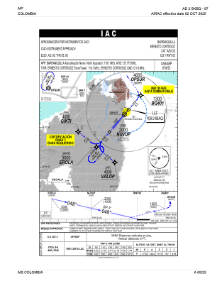
 IAC chart of SKBQ
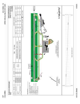
 ADC chart of SKBQ
 Satellite view of SKBQ

IAC chart of SKBQADC chart of SKBQ
Satellite view of SKBQ
Sorry, we have no imagery here.
Sorry, we have no imagery here.
Sorry, we have no imagery here.
Sorry, we have no imagery here.
Sorry, we have no imagery here.
Sorry, we have no imagery here.


SKBQ - Barranquilla-Ernesto Cortissoz
Located in Barranquilla, Colombia
ICAO - SKBQ, IATA - BAQ
Data provided by AirmateGeneral information
Coordinates: N10°53'22" W74°46'50"
Elevation is 95 feet MSL.
Magnetic variation is -8° East View others Airports in Atlántico
Operational data
Special qualification required
Current time UTC: 11:14:43
Current local time:
Weather
METAR: SKBQ 251100Z 03007KT CAVOK 27/24 Q1010
TAF: TAF SKBQ 251055Z 2512/2612 03006KT 9999 FEW015 BECMG 2515/2518 04016KT BECMG 2602/2605 VRB03KT TX32/2519Z TN27/2610Z
Communications frequencies: [VIEW]
Runways:
| RWY identifier | QFU | Length (ft) | Width (ft) | Surface | LDA (ft) |
| 05 | 41° | 9846 | 148 | ASPH | 9846 |
| 23 | 221° | 9846 | 148 | ASPH | 9846 |
Airport contact information
Address: Barranquilla Colombia

